


 Feed
Feed Scan with QR Code Reader
 mobi
mobi- Advertise / Donate
Welcome !
Newquay weather receives over 1000 vistors per day winter time, rising to over 3000 to 4000 or more in the summer, including visitors from all over the world.
Please help support this site

Your business

Via Paypal
- Accommodation
Hotels, B&B's and Caravan and Camping Sites

Porth Sands - Luxury beach accommodation wth beach facing balconies, a golden sandy beach making it the perfect place to idle away the hours- swimming, body boarding, sunbathing and paddling.
- Food
Restaurants, Cafe's, Takeaways

Pachanga - Pachanga Authentic Mexican Since 2016 we've been re-creating dishes that are part of our cultural heritage using techniques that are unique to Mexico. We use mostly Mexican, local & organic produce in our dishes & drinks
- Charity Events
Charity Events - Max 3 free ads
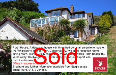
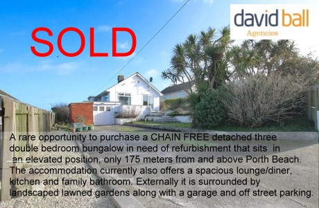
For a Free Charity Ad Here, please contact me- - Houses for Sale
Houses for Sale
Advertise your house for sale here and help support this site.
Small photo, text + link to agents for a One off ₤25. Please contact me.Advertise your house for sale here
- Local Services
Shops, Services etc

Towan Insurance BrokersCornwall's local commercial insurance specialist. We help Cornish businesses find the right cover, from tradespeople and property owners to specialist contractors. Based in Cornwall, independent, and genuinely invested in the businesses we work with. Visit us at Towan Insurance Brokers
UK Earthquakes and European Map
New, Earthquake Seismogram page from Carnmenellis, Cornwall Here
| UK Earthquakes in the last 60 days | ||||
|---|---|---|---|---|
| Updated: 20/06/2026 02:13 | ||||
| Epicenter Near | Magnitude | Distance to Epicenter | Local Time | Link to Map |
| NORTH ATLANTIC OCEAN | 1.4 | 392 mi (631 km) | 18/06/2026 00:51 | Map |
| SILVERDALE,LANCASHIRE | 0.5 | 275 mi (442 km) | 15/06/2026 22:11 | Map |
| PUBIL,PERTH & KINROSS | 0.9 | 422 mi (680 km) | 11/06/2026 05:17 | Map |
| TANWORTH,WARWICKSHIRE | 1.5 | 192 mi (309 km) | 10/06/2026 06:43 | Map |
| SILVERDALE,LANCASHIRE | 0.7 | 276 mi (444 km) | 07/06/2026 20:31 | Map |
| SILVERDALE,LANCASHIRE | 1.1 | 275 mi (443 km) | 07/06/2026 18:13 | Map |
| SILVERDALE,LANCASHIRE | 2.2 | 275 mi (443 km) | 06/06/2026 22:35 | Map |
| LOCHBROOM,HIGHLAND | 1.0 | 507 mi (817 km) | 05/06/2026 06:14 | Map |
| ATHERTON,GTR MANCHESTER | 1.4 | 240 mi (387 km) | 31/05/2026 22:55 | Map |
| INVERIE,HIGHLAND | 0.4 | 459 mi (739 km) | 31/05/2026 00:38 | Map |
| PUBIL,PERTH & KINROSS | 0.8 | 423 mi (681 km) | 29/05/2026 20:04 | Map |
| PUBIL,PERTH & KINROSS | 0.5 | 423 mi (681 km) | 29/05/2026 09:04 | Map |
| SOUTHERN NORTH SEA | 2.3 | 417 mi (672 km) | 26/05/2026 22:11 | Map |
| BADACHRO,HIGHLAND | 0.8 | 504 mi (811 km) | 26/05/2026 04:39 | Map |
| ENGLISH CHANNEL | 2.2 | 253 mi (408 km) | 24/05/2026 21:10 | Map |
| LOCHALINE,HIGHLAND | 0.9 | 424 mi (682 km) | 22/05/2026 00:27 | Map |
| BRAMHAM,WEST YORKSHIRE | 1.2 | 284 mi (458 km) | 21/05/2026 23:44 | Map |
| BARRISDALE,HIGHLAND | 2.6 | 459 mi (738 km) | 20/05/2026 13:23 | Map |
| DALAVICH,ARGYLL & BUTE | 0.9 | 405 mi (651 km) | 19/05/2026 11:23 | Map |
| CELTIC SEA | 0.8 | 134 mi (216 km) | 17/05/2026 13:08 | Map |
| PUBIL,PERTH & KINROSS | 0.1 | 422 mi (679 km) | 17/05/2026 05:38 | Map |
| LERAGS,ARGYLL & BUTE | 0.5 | 410 mi (660 km) | 17/05/2026 00:55 | Map |
| SILVERDALE,LANCASHIRE | 2.3 | 275 mi (442 km) | 13/05/2026 10:11 | Map |
| WISTON,DYFED | 1.4 | 98 mi (158 km) | 12/05/2026 19:22 | Map |
| BROTTON,NORTH YORKSHIRE | 1.7 | 333 mi (536 km) | 12/05/2026 14:13 | Map |
| LLANBISTER,POWYS | 2.7 | 153 mi (247 km) | 12/05/2026 08:33 | Map |
| GLENDARUEL,ARGYLL/BUTE | 0.7 | 387 mi (623 km) | 11/05/2026 02:16 | Map |
| MULL,ARGYLL & BUTE | 1.9 | 430 mi (692 km) | 10/05/2026 05:33 | Map |
| MULL,ARGYLL & BUTE | 1.1 | 426 mi (686 km) | 09/05/2026 14:11 | Map |
| GLENSANDA,HIGHLAND | 1.1 | 428 mi (689 km) | 09/05/2026 00:31 | Map |
| GLENSANDA,HIGHLAND | 1.1 | 427 mi (688 km) | 08/05/2026 23:16 | Map |
| IRISH SEA | 0.6 | 240 mi (386 km) | 08/05/2026 03:18 | Map |
| MULL,ARGYLL & BUTE | 1.4 | 427 mi (688 km) | 07/05/2026 20:18 | Map |
| CALLANDER,STIRLING | 0.9 | 402 mi (647 km) | 06/05/2026 08:17 | Map |
| KINLOCH HOURN,HIGHLAND | 1.1 | 460 mi (741 km) | 02/05/2026 23:16 | Map |
| IRISH SEA | 0.2 | 235 mi (377 km) | 02/05/2026 18:20 | Map |
| LITTON,NORTH YORKSHIRE | 0.8 | 285 mi (458 km) | 02/05/2026 08:25 | Map |
| KINLOCH HOURN,HIGHLAND | 0.9 | 460 mi (740 km) | 02/05/2026 05:54 | Map |
| SOUTHERN NORTH SEA | 2.2 | 307 mi (495 km) | 01/05/2026 18:52 | Map |
| ABINGTON,LANARKSHIRE | 0.9 | 355 mi (571 km) | 30/04/2026 05:28 | Map |
| INNERLEITHEN,BORDERS | 1.0 | 366 mi (589 km) | 30/04/2026 01:25 | Map |
| ACHALLADER,ARGYLL/BUTE | 0.1 | 427 mi (687 km) | 28/04/2026 04:45 | Map |
| PUBIL,PERTH & KINROSS | 0.2 | 423 mi (681 km) | 28/04/2026 03:14 | Map |
| BATH,SOMERSET | 1.8 | 134 mi (216 km) | 27/04/2026 01:52 | Map |
44 UK Earthquakes in the last 60 days.
Reproduced with the permission of the British Geological Survey © NERC. All rights Reserved.
Based upon KML Data Feeds, with the permission of the British Geological Survey.
Check out the UK Earthquake Timeline 1970 to Present Day Here from the British Geological Survey
Cornwall Map of Historical Earthquakes
Local Earthquakes |
|
July 2014
The higest level of detections in the last decade is set to be registered for 2014 with 100 earthquakes recorded in the first 3 months of the year and 149 in total up until July.
This compares to 154 in 2013, 64 in 2006 and 111 in 2005. |
| 17:26 on 23rd July 2014 - Jersey - 3.2 magnitude |
| 12:54 on 11th July 2014 - Jersey - 4.2 magnitude |
| 10th November 1996 - Centred on Mounts Bay, near Penzance. 3.8 on the Richter Scale |
| 25 February and 12 June 1981 Here Constantine and Liskard |
| ------------- |
|
The average recurrence the UK may expect can be estimated as follows: an earthquake of 3.7 or larger every 1 year an earthquake of 4.7 or larger every 10 years an earthquake of 5.6 or larger every 100 years. |
Cornwall Geology Map -Sorry you will have to zoom in.
Europe RSS Feed
Unable to open RSS Feed $XMLfilename with error HTTP ERROR: 404, exiting

)